
We left Germany late Sunday morning and had an easy drive back to France. It rained a bit but before long the sun was shining and we cruised right along the autobahn. We took a different way this time – missing Frankfurt altogether in fact. We headed west toward Wiesbaden, then around Mainz and were soon back in “Frankreich.” If we didn’t have to slow down going past the old customs booths we would hardly have noticed the border even existed. Even the signs informing you of passing from one country to another are small and quite inconspicuous. I wonder if North Americans couldn’t learn something here, but I doubt it. (photo: Ossuary on the battlefield.)
After a four hour drive we reached our Verdun turnoff – we decided to take a back road toward the town and so we cruised along the Lorraine countryside for some 20 kms or so before reaching this most historic of World War One cities, where we promptly got lost.

OK we weren’t lost per se – we knew where we were we just couldn’t find our hotel, the “Hostellerie du coq Hardi”. They had emailed us a map – apparently drawn by a drunk 6-year-old -- showing how to find the hotel, which was right in the historic city center and along the river. Of course they failed to tell us about the one-way streets or that we had to unload in one place and then drive to park somewhere else entirely. No, they didn’t. so naturally the result was we could not for the life of us see the hotel anywhere it was supposed to be (based on the map we had), and consequently we found ourselves going around and around and around in circles, crossing and recrossing the river Meuse several times. We decided enough was enough. So we stopped, parked and started walking the streets with our lousy little map. Rather than driving around aimlessly we were now walking in circles. We walked and walked, around and around, and when we stopped in a café to ask they pointed “over there” and so we went “over there” and saw nothing. Up and down the river we walked. And then came a revelation from on high: there was the hotel – a huge building with an even bigger sign on its roof: “du coq Hardi” with a flashing green arrow pointing to an enormous rooster. (photo above: the Verdun memorial in town and our hotel on the right; below: Meuse River passing through Verdun; our hotel is just to the right of the camera.)

As we checked in we learned that the hotel’s restaurant would be closed for the evening, it being Sunday, and indeed most of the town’s restaurants would be closed as well. Regarding the hotel, aside from their terrible directions, we can recommend it primarily for the location: virtually on the river and close to everything in the downtown area plus it is only a 10-minute drive to the battlefield. Our room was large, although the floors were creaky and tilted a bit. The bathroom was equally spacious but had that hand-held shower which I loathe but obviously others prefer – you know the one: where you squat in the tub like, well never mind what it’s like. So you squat and hose down and then hose off and out. There was small lift (2 persons maximum), one with that sliding metal screen door right out of a Hitchcock film. I kept looking for Jimmy Stewart to come tearing down the hall.
So we unpacked, refreshed ourselves and then got ready for the battlefield hike.
We had talked about maybe doing the hike on Monday before returning to the city – but it was still early in the day, the sun was out and seemed determined to stay that way and so we headed back out of town toward the Verdun battlefield.
For our brief tour of the battlefield we relied heavily on Christina Holstein’s Fort Douaumont: Verdun (the Battleground Europe series) for providing both the central details of the 10-month long battle in 1916 around Verdun, which cost hundreds of thousands of French and German lives, and a nicely laid out walking/driving tour. Her book is also useful for touring Fort Douaumont itself, where much of the original interior space is accessible today. But be forewarned: the tunnels are very damp, cold and plenty of water on the floor so wear the appropriate clothes, particularly footwear.
I cannot emphasize enough how important it is to have a good, easy-to-use guidebook here. The battleground covers so much physical space and walking is really the best way to see many places on the field. There is an excellent guide-map of the battlefield (in three languages) that is available in the Verdun memorial and museum bookshop near the destroyed village of Fleury. It sells for €10 and I should think an absolute necessity for the serious walker/hiker of the battlefield. (Most of the present battlefield park is owned by the state so walking and biking are rarely an issue.)
For online resources check out:
http://www.verdun-douaumont.com/en/index.html
http://www.ingrid-tourisme-verdun.com/
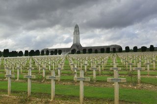
After leaving Verdun we climbed up from the valley floor to the nearby ridgeline toward the battlefield, giving an absolutely spectacular view of the Meuse valley and the town of Verdun. We drove past the Memorial de Verdun and the destroyed village of Fleury to the large car park next to the Ossuary and national cemetery. Officially inaugurated in 1932 the Ossuary contains the remains of some 130,000 French and German soldiers who fell at Verdun. At some 46 meters high the tower of the Ossuary is probably the most conspicuous land mark on the battlefield, and is placed in middle of a central gallery which runs for 137 meters, containing 42 alcoves where you can see the sarcophagi arranged according to which part of the battlefield the remains came from. The Ossuary looks quite like the hilt of a sword buried in the ground. You can climb to the top of the tower for a panorama of the battlefield, and there is also a bookshop on the lower level. (photo above: the Ossuary and National Cemetery.)
We left our car and after touring the Ossuary briefly we started walking along the road toward the village of Douaumont. (We were using Holstein’s suggested walking tour here.)


One of the first things you notice about the entire battlefield is the land, or rather the shape of the land – it is all lip-to-lip craters, like a lunar landscape but covered with trees, allowing one to get just a hint at what it looked like as more than 2 million shells pummeled the battlefield during the 10 months of fighting in 1916. (photos above: from the village of Fleury, one of the central parts of the battlefield -- picture it without the trees and green growth, just dirt, mud and the occasional stagnant water pool.)

And there is no better place to see the impact than on the nine villages which were at one time on the site of the present battlefield. One of nine villages destroyed during the fighting in 1916, Douaumont, like the other eight, was never rebuilt, the handful of survivors moving elsewhere. (Although every October there is a memorial mass service held in the tiny chapel Douaumont, which was built over the remains of the original church.) The original buildings and homes of the village are all outlined with small white markers noting who lived there and what they did (plumber, winegrower, etc.). It’s very eerie actually, strolling down streets devoid of all signs of life except for those small markers in the ground hinting at the lives that had gone on here for centuries and that were snuffed out in such waves of destruction that it is virtually unimaginable today. (photo above: Douaumont village before 1916; below: Douaumont village, 2006.)

To find out more about the destroyed villages in Verdun, click here.
From Douaumont village we took a footpath across country toward Fort Douaumont, one of the central elements of the Verdun battlefield, some 800 meters away. Along the way through the undergrowth and trees one can really see the profound changes to the topography; as you climb toward the fort you have to maneuver around the constantly undulating ground and the pools of black, stagnant water. As you look through the forest around you the ground in fact appears to be massive green waves on an ocean frozen in a moment’s upheaval ready to crash down again at any minute. The word is that there are still plenty of unexploded devices out there. We didn’t stray off the path.(photo below: Susan standing next to a machine gun turret on the "roof" of Fort Douaumont, Verdun battlefield.)

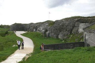
We were brought back to the present as we stumbled into the car park next to the fort. We wandered around the exterior features, checking out the observation posts and the various gun turrets. The roof of the fort looks much like the surrounding terrain I might add since it was one of the featured targets during the months of shelling (first by the Germans taking it from the French and then by the French taking it back from the Germans.) We walked back to where we had started and found the entrance. We paid the entrance fee of €3 per person and walked into the main tunnel. (photo below: exterior of the fort today.)
Unlike most forts we think of today the French fort system in the late 19th and early 20th century were actually underground complexes of tunnels, leading out from a complex of living areas and supply spaces to the machine gun turrets, observation posts and of course the big gun turrets, the 75mm and 155mm guns which were the central feature of these forts. (photo below: 75mm turret raised to firing position.)

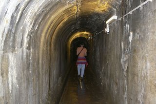
There are in fact several levels to the fort and you’re pretty much on your own in finding your way around. (photo above: one of the corridors inside the fort.) Fortunately the signage is good – and multilingual – so you can get a sense of the major features of the fort’s interior: the washroom, the barracks room, the kitchen, laundry, bakery and so on. You can even see the mechanical system involved in raising and lowering the big 155mm gun turret – the turrets were raised to fire and then lowered to protect the guns from artillery barrages. One of the most poignant features of the fort’s interior is the “German cemetery.” During the brief period of time that the Germans occupied the fort in 1916 there was explosion inside that killed more than 600 soliders who were trapped in the living areas. When rescuers tried to extricate the bodies they found the carnage so extensive that they simply sealed up the rooms, or rather casemates where the men had died and today there is a memorial at the bricked up wall.

From the fort we continued our walk back in the direction of the Ossuary, passing a couple of combat shelters as well as a communications trench from 1916:

After a brief walk we eventually ended up at the National Cemetery. Some 15,000 French soldiers are interred in the cemetery including a large number of Muslims (whose stones face east); there is also a large memorial in a mosque-like structure honoring the muslim troops for their part in the war.
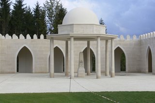
On the other side of the cemetery is a large memorial honoring the French Jewish soldiers who died at Verdun as well.
After returning to our car we drove to the nearby abandoned village of Fleury where we walked around for a bit, looking for insight as to what happened here. There were of course the markers delineating the homes and shops that had once been the village, but unlike at Douaumont, there were even signposts noting the streets that had once bustled with life and were now empty of everything except memories and the green growth of time.
From Fleury we stopped at the large memorial and museum a couple of hundred meters away – but since they were getting ready to close we only browsed the bookshop.
The shadows were lengthening but we still had some good sun left so we continued our drive around the battlefield visiting several other nearby sites before returning to the town of Verdun and our hotel.

In particular I wanted to stop at the "Tranchée des Baionettes", the trench of the bayonets, located about a 3-minute drive from the Ossuary. The story goes that between June 10 and June 12, 1916, the men of the French 137th regiment suffered intense bombardment by super-heavy German guns, including 280mm and 305mm howitzers. In 1919 when the former colonel returned to the battlefield he found the trench where a number of his men hadv apparently been buried alive as only their rifles (and supposedly their bayonets) protruded from the dirt. In 1920 the trench was excavated and some 47 bodies were found, 14 of which were identified. An American banker, George Rand, saw a photograph of the "trench" prior to its excavation and was so moved that he raised more than 500,000 francs to build the concrete memorial which today hovers directly above the trench. (photos above and below: memorial at the trench of the bayonets.)

As restaurant choices were slim for the evening, mainly lots of café types along the river, we ended up eating at a place just around the corner from our hotel as it turned out: “La Table de Alsatien” (the “Alsatian Table”). The food was good, service interesting and prices reasonable. Shortly after we sat down a man was seated at the table next to us. Later on John introduced himself – after hearing us speaking English – and it turns out he was from Texas and had been visiting in Germany but wanted to come to Verdun to tour the battlefield so here he was for a couple of nights; and staying at the same hotel! We chatted for a bit about Verdun sharing some of our thoughts about what we had seen during the day. He had arrived late so he hadn’t been able to get out to the field yet.
After saying goodnight to John and wishing him a successful trip to the battlefield Susan and I turned in for the evening.
We awoke to overcast skies, blustery winds and rainy weather. While we counted ourselves fortunate to have made our tour of the battlefield the day before, we felt a little sorry for John. As we checked out of the hotel I caught him eating his breakfast in the hotel dining room and wished him well and good luck.
We found our way back to the car park, loaded up and headed out of town and toward the A4 for Paris. Signage for getting to the A4 was good but took us forever to get out of town – or so it seemed to us anyway. But before long we were on our way humming down the “Voie Sacreé”, the “sacred way”, which is the highway that the French used to bring supplies from Bar-le-Duc to Verdun during the battle in 1916 and is memorialized today by a series of mile markers as well as a large memorial not far outside of the city. (In fact every November 11th there is an organized hike of the Voie Sacreé.)
A couple of hours later found us zooming past the exit to EuroDisney just east of Paris – we didn’t get off though. Soon afterwards we pulled into the Holiday Inn near Orly airport, dropped the car off and began our trek back into the city and home.
In the space of one week we had the great good fortune to have visited two of history’s major fields of conflict: the D-Day beaches at Normandy and Verdun. We were simply awed and in some ways overwhelmed by both. I hope that any American planning a trip to this part of the world will figure some way to include one or the other or both in their itinerary. You’ll do yourself a favor and at the same time pay homage to so many who gave their lives so that we might get on with ours.
Wish you were here – and there,
Steve

After a four hour drive we reached our Verdun turnoff – we decided to take a back road toward the town and so we cruised along the Lorraine countryside for some 20 kms or so before reaching this most historic of World War One cities, where we promptly got lost.

OK we weren’t lost per se – we knew where we were we just couldn’t find our hotel, the “Hostellerie du coq Hardi”. They had emailed us a map – apparently drawn by a drunk 6-year-old -- showing how to find the hotel, which was right in the historic city center and along the river. Of course they failed to tell us about the one-way streets or that we had to unload in one place and then drive to park somewhere else entirely. No, they didn’t. so naturally the result was we could not for the life of us see the hotel anywhere it was supposed to be (based on the map we had), and consequently we found ourselves going around and around and around in circles, crossing and recrossing the river Meuse several times. We decided enough was enough. So we stopped, parked and started walking the streets with our lousy little map. Rather than driving around aimlessly we were now walking in circles. We walked and walked, around and around, and when we stopped in a café to ask they pointed “over there” and so we went “over there” and saw nothing. Up and down the river we walked. And then came a revelation from on high: there was the hotel – a huge building with an even bigger sign on its roof: “du coq Hardi” with a flashing green arrow pointing to an enormous rooster. (photo above: the Verdun memorial in town and our hotel on the right; below: Meuse River passing through Verdun; our hotel is just to the right of the camera.)

As we checked in we learned that the hotel’s restaurant would be closed for the evening, it being Sunday, and indeed most of the town’s restaurants would be closed as well. Regarding the hotel, aside from their terrible directions, we can recommend it primarily for the location: virtually on the river and close to everything in the downtown area plus it is only a 10-minute drive to the battlefield. Our room was large, although the floors were creaky and tilted a bit. The bathroom was equally spacious but had that hand-held shower which I loathe but obviously others prefer – you know the one: where you squat in the tub like, well never mind what it’s like. So you squat and hose down and then hose off and out. There was small lift (2 persons maximum), one with that sliding metal screen door right out of a Hitchcock film. I kept looking for Jimmy Stewart to come tearing down the hall.
So we unpacked, refreshed ourselves and then got ready for the battlefield hike.
We had talked about maybe doing the hike on Monday before returning to the city – but it was still early in the day, the sun was out and seemed determined to stay that way and so we headed back out of town toward the Verdun battlefield.
For our brief tour of the battlefield we relied heavily on Christina Holstein’s Fort Douaumont: Verdun (the Battleground Europe series) for providing both the central details of the 10-month long battle in 1916 around Verdun, which cost hundreds of thousands of French and German lives, and a nicely laid out walking/driving tour. Her book is also useful for touring Fort Douaumont itself, where much of the original interior space is accessible today. But be forewarned: the tunnels are very damp, cold and plenty of water on the floor so wear the appropriate clothes, particularly footwear.
I cannot emphasize enough how important it is to have a good, easy-to-use guidebook here. The battleground covers so much physical space and walking is really the best way to see many places on the field. There is an excellent guide-map of the battlefield (in three languages) that is available in the Verdun memorial and museum bookshop near the destroyed village of Fleury. It sells for €10 and I should think an absolute necessity for the serious walker/hiker of the battlefield. (Most of the present battlefield park is owned by the state so walking and biking are rarely an issue.)
For online resources check out:
http://www.verdun-douaumont.com/en/index.html
http://www.ingrid-tourisme-verdun.com/
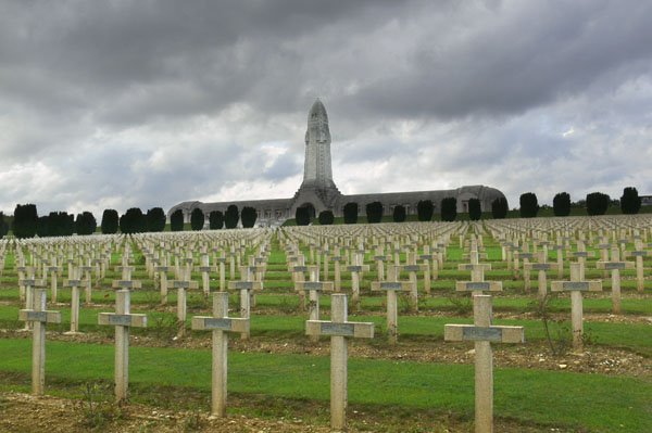
After leaving Verdun we climbed up from the valley floor to the nearby ridgeline toward the battlefield, giving an absolutely spectacular view of the Meuse valley and the town of Verdun. We drove past the Memorial de Verdun and the destroyed village of Fleury to the large car park next to the Ossuary and national cemetery. Officially inaugurated in 1932 the Ossuary contains the remains of some 130,000 French and German soldiers who fell at Verdun. At some 46 meters high the tower of the Ossuary is probably the most conspicuous land mark on the battlefield, and is placed in middle of a central gallery which runs for 137 meters, containing 42 alcoves where you can see the sarcophagi arranged according to which part of the battlefield the remains came from. The Ossuary looks quite like the hilt of a sword buried in the ground. You can climb to the top of the tower for a panorama of the battlefield, and there is also a bookshop on the lower level. (photo above: the Ossuary and National Cemetery.)
We left our car and after touring the Ossuary briefly we started walking along the road toward the village of Douaumont. (We were using Holstein’s suggested walking tour here.)


One of the first things you notice about the entire battlefield is the land, or rather the shape of the land – it is all lip-to-lip craters, like a lunar landscape but covered with trees, allowing one to get just a hint at what it looked like as more than 2 million shells pummeled the battlefield during the 10 months of fighting in 1916. (photos above: from the village of Fleury, one of the central parts of the battlefield -- picture it without the trees and green growth, just dirt, mud and the occasional stagnant water pool.)
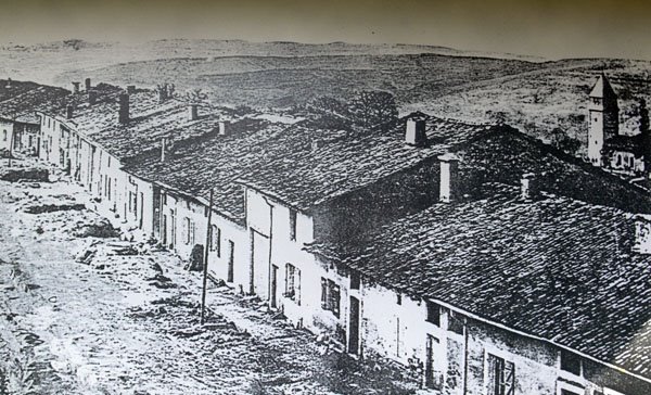
And there is no better place to see the impact than on the nine villages which were at one time on the site of the present battlefield. One of nine villages destroyed during the fighting in 1916, Douaumont, like the other eight, was never rebuilt, the handful of survivors moving elsewhere. (Although every October there is a memorial mass service held in the tiny chapel Douaumont, which was built over the remains of the original church.) The original buildings and homes of the village are all outlined with small white markers noting who lived there and what they did (plumber, winegrower, etc.). It’s very eerie actually, strolling down streets devoid of all signs of life except for those small markers in the ground hinting at the lives that had gone on here for centuries and that were snuffed out in such waves of destruction that it is virtually unimaginable today. (photo above: Douaumont village before 1916; below: Douaumont village, 2006.)

To find out more about the destroyed villages in Verdun, click here.
From Douaumont village we took a footpath across country toward Fort Douaumont, one of the central elements of the Verdun battlefield, some 800 meters away. Along the way through the undergrowth and trees one can really see the profound changes to the topography; as you climb toward the fort you have to maneuver around the constantly undulating ground and the pools of black, stagnant water. As you look through the forest around you the ground in fact appears to be massive green waves on an ocean frozen in a moment’s upheaval ready to crash down again at any minute. The word is that there are still plenty of unexploded devices out there. We didn’t stray off the path.(photo below: Susan standing next to a machine gun turret on the "roof" of Fort Douaumont, Verdun battlefield.)

We were brought back to the present as we stumbled into the car park next to the fort. We wandered around the exterior features, checking out the observation posts and the various gun turrets. The roof of the fort looks much like the surrounding terrain I might add since it was one of the featured targets during the months of shelling (first by the Germans taking it from the French and then by the French taking it back from the Germans.) We walked back to where we had started and found the entrance. We paid the entrance fee of €3 per person and walked into the main tunnel. (photo below: exterior of the fort today.)

Unlike most forts we think of today the French fort system in the late 19th and early 20th century were actually underground complexes of tunnels, leading out from a complex of living areas and supply spaces to the machine gun turrets, observation posts and of course the big gun turrets, the 75mm and 155mm guns which were the central feature of these forts. (photo below: 75mm turret raised to firing position.)


There are in fact several levels to the fort and you’re pretty much on your own in finding your way around. (photo above: one of the corridors inside the fort.) Fortunately the signage is good – and multilingual – so you can get a sense of the major features of the fort’s interior: the washroom, the barracks room, the kitchen, laundry, bakery and so on. You can even see the mechanical system involved in raising and lowering the big 155mm gun turret – the turrets were raised to fire and then lowered to protect the guns from artillery barrages. One of the most poignant features of the fort’s interior is the “German cemetery.” During the brief period of time that the Germans occupied the fort in 1916 there was explosion inside that killed more than 600 soliders who were trapped in the living areas. When rescuers tried to extricate the bodies they found the carnage so extensive that they simply sealed up the rooms, or rather casemates where the men had died and today there is a memorial at the bricked up wall.

From the fort we continued our walk back in the direction of the Ossuary, passing a couple of combat shelters as well as a communications trench from 1916:

After a brief walk we eventually ended up at the National Cemetery. Some 15,000 French soldiers are interred in the cemetery including a large number of Muslims (whose stones face east); there is also a large memorial in a mosque-like structure honoring the muslim troops for their part in the war.

On the other side of the cemetery is a large memorial honoring the French Jewish soldiers who died at Verdun as well.
After returning to our car we drove to the nearby abandoned village of Fleury where we walked around for a bit, looking for insight as to what happened here. There were of course the markers delineating the homes and shops that had once been the village, but unlike at Douaumont, there were even signposts noting the streets that had once bustled with life and were now empty of everything except memories and the green growth of time.
From Fleury we stopped at the large memorial and museum a couple of hundred meters away – but since they were getting ready to close we only browsed the bookshop.
The shadows were lengthening but we still had some good sun left so we continued our drive around the battlefield visiting several other nearby sites before returning to the town of Verdun and our hotel.

In particular I wanted to stop at the "Tranchée des Baionettes", the trench of the bayonets, located about a 3-minute drive from the Ossuary. The story goes that between June 10 and June 12, 1916, the men of the French 137th regiment suffered intense bombardment by super-heavy German guns, including 280mm and 305mm howitzers. In 1919 when the former colonel returned to the battlefield he found the trench where a number of his men hadv apparently been buried alive as only their rifles (and supposedly their bayonets) protruded from the dirt. In 1920 the trench was excavated and some 47 bodies were found, 14 of which were identified. An American banker, George Rand, saw a photograph of the "trench" prior to its excavation and was so moved that he raised more than 500,000 francs to build the concrete memorial which today hovers directly above the trench. (photos above and below: memorial at the trench of the bayonets.)

As restaurant choices were slim for the evening, mainly lots of café types along the river, we ended up eating at a place just around the corner from our hotel as it turned out: “La Table de Alsatien” (the “Alsatian Table”). The food was good, service interesting and prices reasonable. Shortly after we sat down a man was seated at the table next to us. Later on John introduced himself – after hearing us speaking English – and it turns out he was from Texas and had been visiting in Germany but wanted to come to Verdun to tour the battlefield so here he was for a couple of nights; and staying at the same hotel! We chatted for a bit about Verdun sharing some of our thoughts about what we had seen during the day. He had arrived late so he hadn’t been able to get out to the field yet.
After saying goodnight to John and wishing him a successful trip to the battlefield Susan and I turned in for the evening.
We awoke to overcast skies, blustery winds and rainy weather. While we counted ourselves fortunate to have made our tour of the battlefield the day before, we felt a little sorry for John. As we checked out of the hotel I caught him eating his breakfast in the hotel dining room and wished him well and good luck.
We found our way back to the car park, loaded up and headed out of town and toward the A4 for Paris. Signage for getting to the A4 was good but took us forever to get out of town – or so it seemed to us anyway. But before long we were on our way humming down the “Voie Sacreé”, the “sacred way”, which is the highway that the French used to bring supplies from Bar-le-Duc to Verdun during the battle in 1916 and is memorialized today by a series of mile markers as well as a large memorial not far outside of the city. (In fact every November 11th there is an organized hike of the Voie Sacreé.)
A couple of hours later found us zooming past the exit to EuroDisney just east of Paris – we didn’t get off though. Soon afterwards we pulled into the Holiday Inn near Orly airport, dropped the car off and began our trek back into the city and home.
In the space of one week we had the great good fortune to have visited two of history’s major fields of conflict: the D-Day beaches at Normandy and Verdun. We were simply awed and in some ways overwhelmed by both. I hope that any American planning a trip to this part of the world will figure some way to include one or the other or both in their itinerary. You’ll do yourself a favor and at the same time pay homage to so many who gave their lives so that we might get on with ours.
Wish you were here – and there,
Steve

No comments:
Post a Comment